UNIT 1. THE EARTH
1. THE EARTH AND THE UNIVERSE.
1. 1. The universe.
The universe appeared 13. 700 million years ago with the “Big Bang”, the explosión of a small mass which contained all the existing matter and energy.
The universe is made of:
- Stars a celestial body which produces its own light and heat.
- other celestial bodies:
- planets, a celestial body which rotates around a star and does not produces its own light and heat. Saturn.

- satellites, a celestial body which rotates around a planet.

- •interestelar matter (dust and gas).
1. 2. The Milky Way.
In the universe, there are millions of groups of stars called galaxies. Each one of them contains thousands of million of stars and planetary systems. One of them is the Milky Way, in which the Solar System is located.

1. 3. The Solar System.
The Solar System is the planetary system to which the Earth Belongs. It was formed about 5.000 million years ago. It consists of eight planets (Mercury, Venus, Earth, Mars, Jupiter, Saturn, Uranus, Neptune) and another celestial bodies (asteroids, satellites and comets) which move around a star of average size, the Sun.

1. 4. Why the Earth is a living planet?
The Earth is the only planet in the Solar System, and the only known planet, where there is life. Life appeared in Earth about 2.000 million years ago. There are three characteristics that explain this:
1. Abundant supply of liquid water, in the form of oceans and seas. Because of this, it is called the Blue Planet.

2. Moderate temperature, it is not too hot (like Venus) or cold (like Mars). It is located about the right distance from the Sun (around 150 million kilometres).


3. The atmosphere, because:
-Contains gases which are essential for life, such as oxygen.
-The atmosphere protects the Earth from dangerous solar radiation.
The Earth: characteristics.
It was formed 4.600 million years ago. Its main characteristics are:
- Its an imperfect sphere (geoid), wider at the Equator than at the Poles.
- Its surface is 510 million km2, a thousand times the area of Spain.
- Most of its surface is covered by oceans and seas.
- Can be divided in two equal parts across the Equator.

External links:
2. THE EARTH'S MOVEMENTS: Rotation and Revolution.
The Earth is not still in space, it is moving around itself (rotation) and and around the Sun (revolution or translation). This two movements have important consequences for life in Earth.
2. 1. The rotation of the Earth.
Definition: The rotation of the Earth is the turning of the Earth around its imaginary axis, from west to east.
The length of this movement is about 24 hours.
This movement has important consequences:
- Alternation of day and night. As a consequence of this movement the Sun gives light and warmth to one side of the Earth, while the other side of the Earth remains in darkness and cools down.
- The apparent movement of the Sun. As a consequence of the rotation of the Earth from West to East, the Sun "appears" from the East and "disappears from the West. The name of the apparition of the Sun over the horizon is dawn, whereas the name of its dessaparition is dusk. Remember: it is the Earth that it is moving not the Sun.
- Geographic coordinates. The Earth's rotation allow us to identify the cardinal points and locate the position of any point in Earth.
- The division of the day in 24 hous and the establishment of time zones:
The Earth takes 24 hours to rotate completely, because of that we can divide the 360º of the Earth's sphere into 24 time zones that have a separation of 15º. Every place that is situated in the same time zone has the same solar time.
In order to calculate the hour in a time zone we take as a reference the Meridian 0 or Greenwich meridian. We put the clock forward one hour for every time zone we move toward the East and we put the clock back one hour for every time zone we move towards the west from the Meridian 0.

For example, we want to know what time is it in the point B, if in the point A (located near the Greenwich Meridian) is the 12 o'clock. The point B is located at the east of the Greenwich Meridian and there is a difference of five time zones, because of this we have to add five hours and in the point B the time is going to be the 17:00.
In the same way, the point C is located at the west of the Greenwich Meridian and there is a difference of five time zones, because of that we have to extract seven hours and in the point C, the hour is going to be the 5:00.
2. 3. The translation of the Earth (orbit).
Definition: The translation is the movement of the Earth around the Sun, from West to East.
Video: Earth orbit.
The length of this movement is about 365 days, 6 hours and 9 minutes, because of that every four years we have a year of 366 days (leap year).
This movement also has important consequences:
- The aparition of the Seasons of the year.
- The different duration of days and nights. During the summer the Norhtern Hemisphere is facing the Sun. As a consequence the illuminated area is bigger than the dark area and days are longer than nights. On the other hand, during the winter the Northern Hemisphere is no facing the Sun, as a consequence the illumanted area is smoller than the dark are an nights are longer than days.
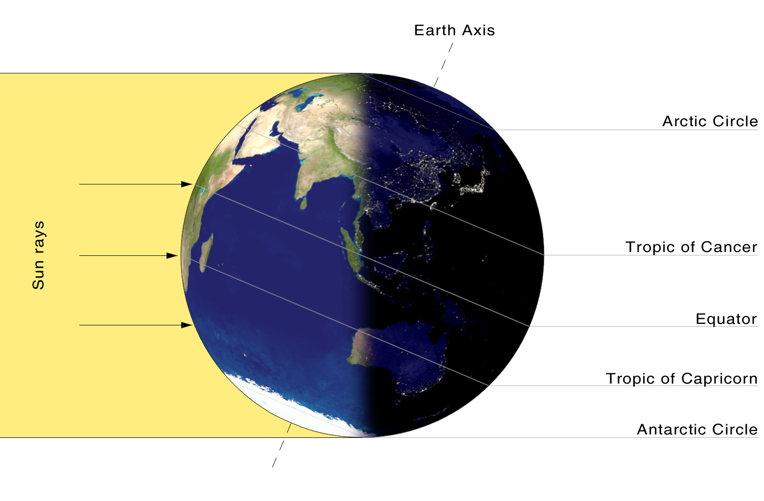
- The apparition of different climate zones. Depending on the latitude, the Sun's rays fall with a different inclination. As a consequence Earth is divided in several climate zones:
- One warm zone.
- Two temperate zones.
- Two cold zones.
3. THE SEASONS: Solstices and equinoxes.
The Earth's axis is gently inclined (about 23º) but always points in the same direction (in the direction of the Polar Star, because of that the Axis orientation do not change even though the Earth is rotantig around the Sun but its position in relation to the Sun does.

3. 1. The seasons of the year.
As a consequence, during different moments of the year the quantity of light and heat that the different parts of the Earth receive from the Sun is going to change during the year:
During summer and winter, the rays of Sun falls directly on one hemisphere while the others reveives them with a strong inclination, making it winter. Nevertheless, during spring and autumn, the rays fall on both hemispheres wiht the same inclination.
When the rays of the Sun are inclined, the same amount of heat is projected onto a larger area, and there is less concentration of heat.
3. 2. Equinox and solstice.
Equinox: is the time of the year when the Sun's rays falls perpendicular to the Equator. The Sun iluminates the North Pole and the South Pole for the same number of hours. There are two equinox:
The spring equinox (March 21), it is spring in the Northern Hemisphere and autumn in the Southern Hemisphere.
The autumn equinox (September 21). it is autum in the Southern Hemisphere and spring in the Southern Hemisphere.

Solstice: is the time of the year when the Sun's rays fall perpendicular to one of the tropics.
There are two solstices:
The Summer solstice (June 21): the Sun is facing the Tropic of Cancer. It is summer in the Northern Hemisphere and winter in the Southern Hemisphere.

The Winter solstice (december 21): the Sun is facing the Tropic of Capricorn. It is summer in the Southern Hemisphere and winter in the Northern Hemisphere.

4.THE GEOGRAPHIC GRID: LATITUDE AND LONGITUDE.
4. 1. The geographic grid.
The Geographic grid is the system of coordinates that we use in order to locate any point in the Earth’s surface.
Both extremes of the Earth´s axis are connected to two fixed points: the poles
From these points we trace imaginary lines that cross with others to form a grid.
4. 2. Parallels and meridians.
This system is based in two types of imaginary lines: parallels and meridians:
Parallels: Imaginary lines that encircle the Earth, perpendicular to its axes.
The main line of latitude is the Equator which divides the Earth into two halves. Another important parallels are the Tropic of Cancer, located in the Northern Hemisphere and the Tropic of Capricorn, located in the Southern Hemisphere.
Meridians: Imaginary semicircles traced from pole to pole.
The most important meridian is the meridian 0º or Greenwich meridian, which runs through Greenwich, near London.

4. 3. Latitude and longitude.
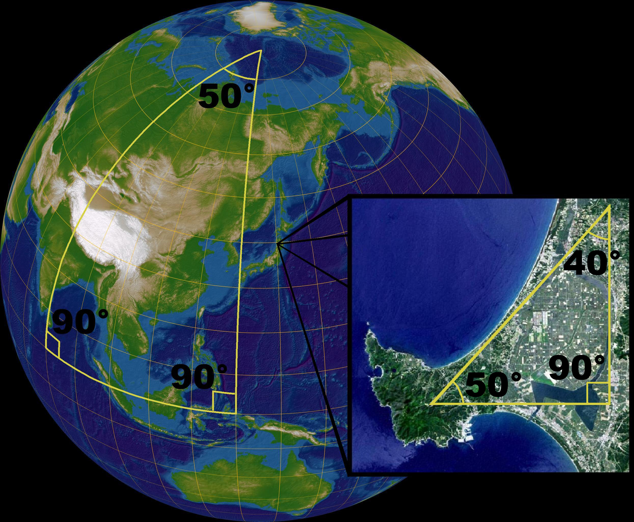
We use this imaginary lines in order to establish the latitude and the longitude of a point located in the Earth’s surface.Latitude: The distance, measured in degrees, from any given point to parallel oº or the equator
The maximum latitude is 90º and can be either north or south.
Latitude: The distance, measured in degrees, from any given point to parallel oº or the equator
The maximum latitude is 90º and can be either north or south.

Longitude: The distance, measured in degrees, from any given point to meridian 0º or Greenwich
The maximum longitude is 180º and can be either east or west.

Remember: every degree (º) can be divided into 60 minutes (') and every minute can be divided into 60 seconds (''), the same way than an a hour. For example, the geographic coordinantes of the IES Cervantes High School are: 40º 24' and 12" N and 3º 42' 8" W.
REPRESENTING THE EARTH: maps and systems of projection.
It is imposible to translate a sphere into a flat surface without change it, the same way that is impossible to flatten the skin of an orange without breaking it, because a flat surface and an sphere have different characteristics.
Because of this a map never is going to be a perfect representation of the Earth's surface.
4. 1. Maps and their elements.
A map is a simplified representation of the Earth's spherical surface, or a part of it, depicted on a flat surface.
In order to make a map, cartographers need three elements:a system of projection, a scale and set of standard sings or legend.
System of projection.
-A system of projection is a system that allow us to represent a spherical surface on a flat surface, translating the network of parallels and meridians.There are three main types of systems of projection:
- cylindrical projection, transfers the grid of parallels and meridians into a cylinder. It is the best method to represent the low latitudes the low latitudes between the Equator and the tropics.

- Conic or conical projection, transfers the grid of parallels and meridians into a cone. It is the best method to represent the mid-latitudes.

- Azimuthal or plane projection, transfers the grid of parallels and meridians into a flat surface. It is the most appropiate method to represent the polar areas.

-Scale is the method that we use to indicate the relation between a distance drawn on the map and the same distance on the ground. There are two types of scale:
- Numerical scale. It is indicates the relationship between the unit used to make the map and the reality. Usually a fraction is used. the numerator indicates the distance on the map and the denominator its equivalent on the ground.

- Graphic scale. It consists of a straigh line divided into segments. Every segment is equivalent to a real distance in the ground.
Legend or key of the map: is a set of colours, standar signs or symbols used to represent reality in the map in a simplified form.
Types of maps:
There are two types of maps:
Topographic or basic maps: represent in detail the physical and human aspects of the territory.
Thematic maps: represent a specific geographica aspect.